10 Best GPS Compasses 2026 in the United States

Related Products
Our technology thoroughly searches through the online shopping world, reviewing hundreds of sites. We then process and analyze this information, updating in real-time to bring you the latest top-rated products. This way, you always get the best and most current options available.
Our Top Picks
Winner
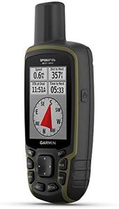
Garmin GPSMAP 65s, Button-Operated Handheld with Altimeter and Compass, Expanded Satellite Support and Multi-Band Technology, 2.6" Color Display
Most important from
403 reviews
The Garmin GPSMAP 65s is a feature-packed handheld GPS compass that stands out with its high accuracy and reliability in challenging environments. This device utilizes expanded global navigation satellite systems (GNSS) and multi-band technology, ensuring precise location tracking even in steep, urban, or densely forested areas. The 2.6-inch color display is sunlight-readable, which makes it easy to view maps and data in bright outdoor conditions.
Its mapping capabilities are enhanced with preloaded TopoActive maps and federal public land boundaries (U.S. only), providing detailed and useful navigation information for outdoor activities like hunting, camping, and hiking. The 3-axis compass and barometric altimeter enhance navigation and provide additional data for users. Additionally, it offers connectivity through Bluetooth, allowing users to manage tracks, routes, and waypoints via the Garmin Explore website and app when paired with a compatible smartphone.
On the downside, the device operates with buttons instead of a touchscreen, which might be less intuitive for some users. The display resolution is relatively low at 160 x 240 pixels, which may not provide the sharpest view. Furthermore, it requires 2 AA batteries, which are included, but frequent replacement might be necessary depending on usage, potentially affecting convenience. At 7.7 ounces, it is lightweight but may feel bulky for some. Despite these drawbacks, the Garmin GPSMAP 65s excels in providing accurate and reliable navigation support for outdoor enthusiasts.
Most important from
403 reviews
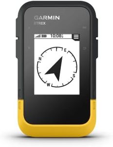
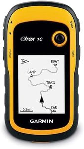
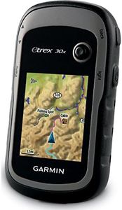
Garmin 010-02256-00 eTrex 22x, Rugged Handheld GPS Navigator, Black/Navy
Most important from
2035 reviews
The Garmin eTrex 22x is a solid choice for outdoor enthusiasts looking for a reliable handheld GPS. It offers impressive accuracy, thanks to support for both GPS and GLONASS satellite systems, which ensures better tracking in difficult environments. This is crucial for activities like hiking and cycling where precision is paramount. The battery life is commendable, lasting up to 25 hours on two AA batteries, making it suitable for long adventures without frequent recharging.
Its durability is another strong point, with a rugged design that can withstand rough handling and challenging weather conditions. The 2.2-inch sunlight-readable color display, though relatively small, provides clear visibility in different lighting conditions. Preloaded Topo Active maps make it easy to navigate trails and roads right out of the box, adding to its convenience.
However, the internal memory of 8 GB may feel limiting for users who need extensive map storage, although this can be expanded with a micro SD card. The inclusion of Bluetooth connectivity is a modern touch, but it might not be as advanced as some higher-end models that offer more robust wireless features. The Garmin eTrex 22x is a durable and reliable GPS navigator with solid battery life and accurate tracking, ideally suited for hikers, cyclists, and campers. Its main drawbacks are the smaller screen size and limited internal memory, but these are counterbalanced by its functionality and dependability.
Most important from
2035 reviews
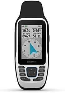
Garmin GPSMAP 79s, Marine GPS Handheld with Worldwide Basemap, Rugged Design and Floats in Water
Most important from
147 reviews
The Garmin GPSMAP 79s is a marine-focused handheld GPS designed to be rugged and reliable. Its key strengths include its durability, with a water-resistant design that floats, making it suitable for marine environments. The device supports multiple satellite constellations (GPS, GLONASS, Beidou, Galileo, QZSS, and SBAS), ensuring accurate tracking worldwide.
The built-in 3-axis electronic compass and barometric altimeter further enhance its accuracy in various conditions. With a battery life of up to 20 hours in GPS mode, it is well-suited for extended periods of use without frequent recharging. The high-resolution color display is scratch-resistant and fogproof, offering clear visibility in different weather conditions.
Mapping capabilities are robust, featuring a worldwide basemap and increased memory capacity to store a significant number of waypoints, routes, and activities. Connectivity is limited to USB, with no wireless options, which may be a drawback for some users. The device's compact size and relatively light weight make it portable and easy to handle, particularly for boating enthusiasts. However, the reliance on AA batteries might require carrying spares on longer trips. Despite these minor shortcomings, the Garmin GPSMAP 79s remains a solid choice for those needing a dependable, marine-ready GPS handheld.
Most important from
147 reviews
Buying Guide for the Best GPS Compasses
When choosing a GPS compass, it's important to consider your specific needs and how you plan to use the device. GPS compasses are essential tools for navigation, whether you're hiking, sailing, or engaging in other outdoor activities. They combine the functionality of a traditional compass with GPS technology to provide accurate directional information. Understanding the key specifications will help you select the best GPS compass for your requirements.FAQ
Most Popular Categories Right Now


