10 Best Hiking Handheld Gps Devices 2026 in the United States


Related Products
Up to 8% off


Our technology thoroughly searches through the online shopping world, reviewing hundreds of sites. We then process and analyze this information, updating in real-time to bring you the latest top-rated products. This way, you always get the best and most current options available.
Our Top Picks
Winner
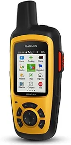
Garmin GPSMAP 67i Rugged GPS Handheld with inReach® Satellite Technology, Two-Way Messaging, Interactive SOS, Mapping
Most important from
354 reviews
The Garmin GPSMAP 67i is a robust handheld GPS device designed for outdoor enthusiasts, particularly hikers. One of its standout features is the comprehensive satellite reception via multi-band GNSS support, ensuring strong and reliable signals even in challenging environments. The two-way messaging and interactive SOS capabilities via the global Iridium satellite network can be lifesavers, though they do require an active subscription.
The device excels in battery life, offering up to 165 hours in 10-minute tracking mode and an impressive 425 hours in expedition mode, making it suitable for extended adventures. Durability is another strong point, with the device being rugged and likely able to withstand tough outdoor conditions. Its 3-inch color display is sunlight-readable, ensuring clear visibility in all lighting conditions. It also comes with preloaded TopoActive maps and access to premium mapping content via an Outdoor Maps+ subscription, which enhances navigation capabilities.
Connectivity options include Bluetooth and USB, allowing for easy data transfer and integration with smartphones for additional features like active weather forecasts and geocaching. However, the device's weight of 8.1 ounces and dimensions of 2.5 x 6.4 x 1.4 inches might be a bit bulky for some users. Additionally, the need for subscriptions for certain features could be a downside for budget-conscious hikers. The Garmin GPSMAP 67i is an excellent choice for serious hikers who prioritize reliability, extensive mapping features, and robust emergency capabilities.
Most important from
354 reviews
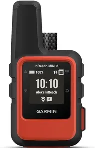
Garmin inReach Mini 2, Lightweight and Compact Satellite Communicator, Hiking Handheld, Orange - 010-02602-00
Most important from
2104 reviews
The Garmin inReach Mini 2 is a compact and lightweight satellite communicator designed for hikers who need reliable global messaging and SOS capabilities. Its small size (about 4 by 2 inches) and light weight (3.5 ounces) make it easy to carry on any trail without feeling bulky. The device offers excellent satellite reception worldwide, allowing two-way text messaging and emergency SOS through an active satellite subscription. This can provide peace of mind in remote areas where cell coverage is unavailable. The battery life is impressive, lasting up to 14 days with 10-minute tracking intervals, so it won’t need frequent recharging during extended trips.
The inReach Mini 2's display is small (1.27 inches) with a modest 176 x 176 resolution, which means maps and texts might appear a bit cramped. It has a touchscreen and Bluetooth connectivity, allowing pairing with smartphones for planning routes and syncing waypoints via the Garmin Explore app. The device includes useful navigation features like the TracBack routing to guide you back to your starting point and a digital compass that works even when you're stationary.
In terms of durability, it is water-resistant, suitable for outdoor conditions but not fully waterproof for deep water exposure. While it doesn’t serve as a full GPS unit with detailed maps onboard, its main strength lies in satellite communication and basic navigation support. This product is best for hikers who prioritize safety and communication in the backcountry and want a lightweight device to stay connected. Those needing detailed offline maps or a larger screen for easier reading might prefer a different GPS device. Yet, for lightweight emergency and messaging functionality with solid battery life, the Garmin inReach Mini 2 remains an excellent choice.
Most important from
2104 reviews
Garmin GPSMAP 65s, Button-Operated Handheld with Altimeter and Compass, Expanded Satellite Support and Multi-Band Technology, 2.6" Color Display
Most important from
401 reviews
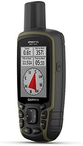
The Garmin GPSMAP 65s is a dependable handheld GPS device designed for hiking and other outdoor activities. It features a large 2.6-inch color display that is easy to read even in sunlight, which is crucial when navigating trails. The device's expanded global navigation satellite systems (GNSS) and multi-band technology ensure high accuracy in diverse and challenging environments, such as dense forests or urban areas with tall buildings. This makes it highly reliable for outdoor adventures where precise location tracking is essential.
Equipped with routable TopoActive maps and U.S. public land maps, the GPSMAP 65s provides detailed navigation options and helps you stay on track in unfamiliar terrains. The 3-axis compass and barometric altimeter add to its navigation capabilities by offering elevation data and directional guidance. Connectivity with the Garmin Explore website and app allows for easy management of routes, waypoints, and tracks, enhancing the user experience.
The device is durable, waterproof, and powered by two AA batteries, which are included. However, the screen resolution of 160 x 240 pixels might not be as sharp as some users prefer, and the reliance on AA batteries could be seen as a downside for those who prefer rechargeable options. Despite these minor drawbacks, the Garmin GPSMAP 65s stands out for its robust features, making it a reliable choice for hikers and outdoor enthusiasts seeking a trustworthy navigation tool.
Most important from
401 reviews
Buying Guide for the Best Hiking Handheld Gps Devices
Choosing the right hiking handheld GPS device can significantly enhance your outdoor adventures by providing accurate navigation, tracking, and safety features. When selecting a GPS device, consider the key specifications that will best suit your hiking needs and preferences. Understanding these specs will help you make an informed decision and ensure you have a reliable companion on your hikes.FAQ
Most Popular Categories Right Now


