10 Best Marine GPS Systems 2026 in the United States


Related Products
Up to 15% off
Our technology thoroughly searches through the online shopping world, reviewing hundreds of sites. We then process and analyze this information, updating in real-time to bring you the latest top-rated products. This way, you always get the best and most current options available.
Our Top Picks
Winner
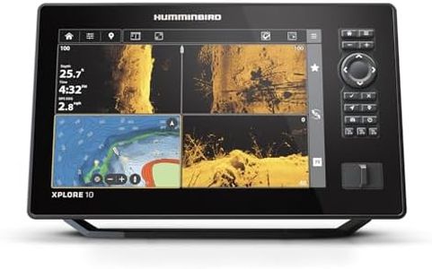
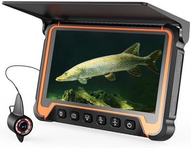
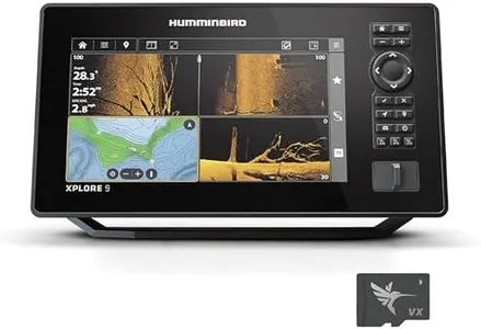
Humminbird XPLORE 10 GPS Fish Finder with Transducer, MEGA Side Imaging+ & HD Touchscreen
Most important from
93 reviews
The Humminbird XPLORE 10 GPS Fish Finder is a strong choice for anglers and boating enthusiasts who want detailed underwater information combined with reliable navigation. Its 10.1-inch full HD touchscreen offers bright, clear visuals, making it easier to see fish and underwater structures even in bright sunlight. The device’s MEGA Side Imaging+ sonar provides an impressive 200-foot range on each side, with sharp detail that helps spot fish and underwater features accurately.
GPS navigation is solid, featuring built-in maps of over 10,000 lakes and compatibility with popular chart systems like Navionics, which is great for both freshwater and coastal use. The AutoChart Live feature lets users create real-time maps of water depth and bottom conditions, a helpful tool for exploring new waters. Connectivity options including Bluetooth, Ethernet, and NMEA 2000 compatibility allow smooth integration with other marine equipment, such as trolling motors and radar.
The unit is designed with durability in mind and is suitable for marine conditions, although exact waterproof ratings are not specified. Some users might find the dual control method—touchscreen plus keypad—initially complex, but it adds versatility once familiar. Weighing under 5 pounds and including essential mounting hardware and a transducer, it’s relatively easy to install. Priced higher than basic fish finders, this model delivers advanced features that serious anglers will appreciate, especially those who want both fishing and navigation capabilities in one device.
Most important from
93 reviews
Garmin ECHOMAP UHD2 94sv with GT56 Transducer, 9" Touchscreen Chartplotter, Garmin Navionics+ U.S. Coastal
Most important from
78 reviews
The Garmin ECHOMAP UHD2 94sv is a solid choice for boating and fishing enthusiasts looking for a reliable marine GPS system. Its standout feature is the 9-inch touchscreen, which is bright and easy to read even in direct sunlight, making navigation a breeze. The touchscreen interface is user-friendly, allowing for quick and easy access to charts and settings. Additionally, its built-in Navionics+ coastal charts provide detailed and accurate mapping, which is crucial for safe navigation along the U.S. coastline.
The inclusion of the GT56 transducer means you get high-quality traditional, ClearVü, and SideVü scanning sonars, offering clear and detailed underwater views. This feature is particularly beneficial for fishing, as it helps identify fish and underwater structures with ease. Connectivity is another strong point, with built-in Wi-Fi allowing you to share sonar data, waypoints, and routes wirelessly with other ECHOMAP UHD2 units. It also connects to the Force trolling motor, enabling you to control the motor directly from the chartplotter, which adds a layer of convenience and efficiency.
On the downside, the unit's weight of 8.08 pounds may be a bit heavy for some users, and its larger size could require more space on the dashboard. The price point may also be higher compared to other similar units, which could be a consideration for budget-conscious buyers. However, with robust features, it offers good value for those willing to invest in a high-quality marine GPS system. This model is best suited for serious boaters and fishers who need reliable, detailed, and easy-to-use navigation and sonar capabilities.
Most important from
78 reviews
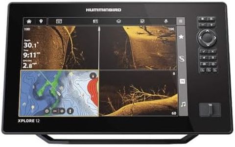
Humminbird XPLORE 12 GPS Fish Finder with Transducer, MEGA Side Imaging+ & HD Touchscreen
Most important from
93 reviews
The Humminbird XPLORE 12 GPS Fish Finder is a solid choice for anglers and boaters who want detailed underwater views and reliable navigation. Its large 12.1-inch HD touchscreen offers sharp visuals, making it easy to read maps and sonar images even in bright daylight. The combination of MEGA Side Imaging+ and MEGA Down Imaging+ sonar technologies provides clear and detailed fish and structure detection up to 200 feet deep, which is impressive for most freshwater and coastal fishing spots.
The built-in GPS paired with pre-loaded maps and compatibility with popular chart cards like LakeMaster and Navionics helps users navigate confidently across thousands of lakes and coastal waters. Connectivity is another strong point, with Bluetooth, Ethernet, and NMEA 2000 support allowing integration with other marine electronics like trolling motors and autopilots. The user interface is friendly, offering both touchscreen and physical buttons, which is handy in rough conditions or if you prefer traditional controls.
At around 6.3 pounds and designed for tabletop mounting, it suits small to medium boats well but might not fit seamlessly on all console layouts. The included three-year warranty adds peace of mind. This fish finder and GPS combo is a great option for fishing enthusiasts who want advanced sonar and reliable navigation features without complicated setup, though those needing ultra-rugged gear or very compact units should consider other options.
Most important from
93 reviews
Buying Guide for the Best Marine GPS Systems
Choosing the right marine GPS system is crucial for ensuring safe and efficient navigation on the water. A marine GPS system helps you determine your exact location, plot routes, and avoid hazards. When selecting a marine GPS system, it's important to consider several key specifications to ensure it meets your needs and enhances your boating experience.FAQ
Most Popular Categories Right Now


